

Products & Services / Defence
Virtual Reality

Virtual Terrain Recce System

A VR console for real, exact visuals and reconnaissance of any terrain from a distant location - giving commanders a detailed 3D view for virtual recce and operational planning, without being physically present.
3D TerrainRealistic View
Virtual RecceAny Location
VR Headset& Controllers
Mission PlanningOperational
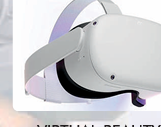
Virtual Reality headset
Immersive VR Headset

Virtual Terrain Recce System

A device for real and exact visuals for reconnaissance of any particular terrain / area from any distant location - a place of one's choice.

Virtual Reality Headset

Overview

With this console, Virtual Terrain Recce of the area of operations is facilitated by integrated hardware & software using Virtual Reality. State-of-the-art VR technology is exploited to give commanders a detailed, 3D realistic view of any terrain - enabling virtual reconnaissance and operational planning without being physically present.

System Components

VR Headset

Virtual Reality Headset

Delivers an immersive, 3D realistic view of the terrain; the scene changes as the head moves left/right and up/down.

Hand Controllers

Hand Controllers

Used to drag, fly over terrain, zoom in/out and perform other operations across the virtual area.
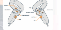
Controller layout

Controller Layout

Thumbsticks, triggers, grip and push buttons mapped for zoom, pointer fixing, rotate, tilt and menu control.

Instructions for Usage

  • Use the left thumbstick to zoom in / out.
  • Use the left trigger to fix the pointer on the ground; use the left grip button to rotate the view.
  • Use the left controller push button to tilt the view; use the right controller push button to enter / exit the menu.

Using this console, the following can be facilitated

  • Search any location on Google Earth.
  • Fly-through experience over the terrain.
  • Detailed virtual terrain reconnaissance.
  • Terrain Recce console with a terrain information model.
  • State-of-the-art technology exploited for virtual recce of terrain.
  • Google Earth VR software on specialist hardware gives a 3D realistic view of the terrain.
  • The area seen changes as the head moves left/right and up/down.
  • Hand controllers drag, fly over terrain, zoom in/out and more.
  • Gives maximum terrain information to commanders for operational planning.